🛡️ The Stone Fortress of the Seven Circuits: The Inimitable Kallina Kote
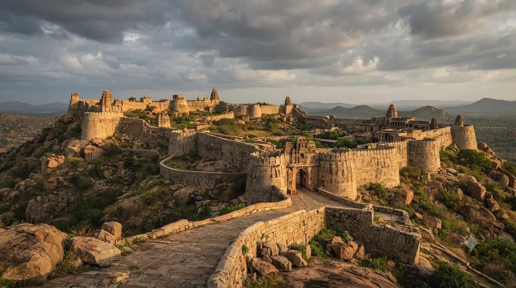
Rising dramatically from the semi-arid plains of central Karnataka, Chitradurga Fort (known anciently as Kallina Kote or the ‘Stone Fort’) represents one of the most ingenious, impenetrable, and expansive hill defense systems in Indian military history. Constructed across centuries by the Rashtrakutas, Hoysalas, and the legendary Nayakas of Chitradurga, the fort incorporates nineteen gateways, thirty-eight watchtowers, thirty-five secret sally ports, and seven concentric stone wall circuits that wind seamlessly around colossal granite boulders, immortalized by the legendary heroism of Onake Obavva.
In the military geography of peninsular India, few fortresses command the formidable tactical reputation of Chitradurga Fort. Located two hundred kilometers northwest of Bengaluru along National Highway 48, this colossal stone citadel spans over one thousand five hundred acres of rugged, boulder-strewn hills. Known colloquially in Kannada as Yelu Suttina Kote (‘The Fort of Seven Rounds’), Chitradurga was engineered so masterfully that it could withstand years of prolonged military siege, relying upon natural granite topography, deceptive entry labyrinths, and revolutionary rainwater-harvesting reservoirs that ensured the garrison never ran dry even in severe Deccan droughts.
The Geological Matrix: Chinmuladri Hills and Granite Boulders
The foundation of Chitradurga’s invincibility lies in its unique geological setting. The fortress is built across a cluster of rugged granite hills anciently known as the Chinmuladri range, rising approximately one hundred and fifty meters above the surrounding Deccan plains. The landscape is characterized by colossal, in-situ granite boulders—some weighing thousands of tons—balanced precariously on steep rocky slopes.
Rather than clearing these boulders, medieval military architects integrated them directly into the defensive walls. Cyclopean granite blocks were dressed with tongue-and-groove joinery and fitted tightly against the natural rock faces without mortar, creating defensive ramparts that appear to grow organically out of the living mountain. This natural camouflage made it virtually impossible for distant enemy artillery to identify the true defensive walls amidst the sea of natural boulders.
The Seven Concentric Wall Circuits (Yelu Suttina Kote)
The fortress is organized into seven concentric rings of defensive stone walls, arranged in an escalating hierarchical sequence:
- The Outer Circuits (Rounds 1 to 3): Located at the base of the hill, enclosing the historic civilian town, commercial bazaars, agricultural fields, and grain storage pits. These lower walls were protected by deep peripheral dry moats, earthen ramparts, and formidable stone gatehouses.
- The Middle Circuits (Rounds 4 and 5): Encircling the intermediate hill slopes, containing military barracks, gunpowder manufacturing mills, artillery gun platforms, and secondary water reservoirs. The gates here are arranged in complex dogleg zig-zag configurations, forcing advancing enemy infantry into narrow defiles where they were exposed to archers and hot oil poured from overhead machicolations.
- The Inner Citadel (Rounds 6 and 7): Perched on the highest, most inaccessible rocky crags, sheltering the royal palaces, treasury chambers, sacred temples, and the supreme command redoubt. Access to this inner sanctum was possible only through narrow, easily defendable rock-cut staircases where a handful of defenders could hold off an entire army.
| Circuit Layer | Elevation / Terrain | Structural Material | Defensive Installations | Tactical Military Objective |
|---|---|---|---|---|
| Outer Rounds 1–3 | Base valley floor | Cyclopean granite blocks | 19 massive gatehouses, dry moats, bastions | Protection of civilian markets, horses, food stocks |
| Middle Rounds 4–5 | Mid-level granite slopes | Interlocking dry-stone masonry | Zig-zag dogleg gateways, gunpowder mills | Funnels attacking cavalry into deadly ambush choke points |
| Inner Rounds 6–7 | High mountain crests | In-situ boulder ramparts | Watchtowers, royal palaces, sacred temples | Ultimate sovereign redoubt and last line of defense |
| Kahi Batha Reservoir | Central hill depression | Stone-lined contour tank | Interconnected rainwater-harvesting network | Guarantees multi-year water autonomy during sieges |
| Onake Obavva Kindi | Narrow rock cleft (Round 5) | Natural granite fissure | Secret watchman post and sally port | Immortal site of lone woman’s defense against soldiers |
The Nayakas of Chitradurga: Valor, Loyalty, and Sovereignty
While the initial fortifications of Chitradurga were established by the Rashtrakutas, Chalukyas, and Hoysalas, the definitive architectural and military zenith of the citadel was achieved under the Nayakas of Chitradurga (Beda Nayakas), who ruled as sovereign monarchs from 1568 to 1779 CE.
Originating as fearless tribal chieftains of the Valmiki community, the Nayakas were appointed as military governors by the Vijayanagara emperors following their valor on battlefield campaigns. Following the collapse of Vijayanagara at Talikota in 1565, legendary ruler Timmanna Nayaka and his successors—most notably Madakari Nayaka V—established an autonomous, fiercely independent martial state. The Nayakas were renowned across South India for their unparalleled physical bravery, expert swordsmanship, and deep devotion to their tutelary deities, Goddess Ekanatheshwari and Lord Uchangi Devi.
The Legend of Onake Obavva: The Immortal Heroine
The name of Chitradurga is eternally immortalized in Indian folklore by the legendary heroism of a brave woman named Onake Obavva. In 1779 CE, the formidable military forces of Hyder Ali, the Sultan of Mysore, laid an unyielding siege to Chitradurga Fort. Unable to breach the seven stone circuits through frontal assault, Hyder Ali discovered a tiny, concealed natural rock crevice—known as a Kindi—that provided secret access through the fifth wall circuit into the inner fort.
The crevice was guarded by a soldier named Kahale Mudda Hanuma. One afternoon, while Hanuma was away eating his lunch, his wife Obavva went to a nearby water hole to fetch drinking water. Suddenly, she heard hushed whispers and spotted enemy soldiers attempting to crawl one by one through the narrow rock opening. Recognizing that sounding an alarm would take too long, Obavva acted with lightning courage.
Armed only with a heavy wooden pestle—an Onake, traditionally used for pounding paddy—Obavva hid beside the narrow opening. As each enemy soldier emerged head-first from the dark hole, Obavva struck him down with a crushing blow of her pestle, dragged the body aside silently, and waited for the next. By the time her husband returned, Obavva had single-handedly slain dozens of enemy soldiers, saving the citadel from surprise betrayal. Although she tragically perished later that evening during the battle, her extraordinary courage made her an immortal folk heroine of Karnataka, celebrated as the embodiment of female valor (Veera Vanitha).
🗡️ Historic Site: Onake Obavva Kindi
Today, visitors to Chitradurga Fort can walk through the exact narrow rock opening, officially preserved as Onake Obavva Kindi. Standing in the cool rock fissure where a lone woman altered military history is an unforgettable, spine-tingling moment of historical reflection.
Hydraulic Masterpiece: Multi-Year Rainwater Harvesting Autonomy
A fortress is only as strong as its water supply. In the arid, rain-shadow plains of central Karnataka where annual precipitation is notoriously low, holding a hill fort against multi-year sieges was considered impossible by conventional military theorists. The Nayakas of Chitradurga solved this existential challenge through a revolutionary interconnected hydraulic grid.
The fort builders constructed thirty-five interconnected masonry tanks, step-wells, and rock-hewn reservoirs—popularly known as the Honda network—strategically positioned across natural drainage basins on the hill. Rainwater falling on the granite summits was captured by contoured stone channels, flowing sequentially through natural silt-settling pools before filling major reservoirs:
- Siriye Honda and Gopala Honda: Deep, perennial natural stone cisterns nestled beneath vertical granite boulders that shielded the water surface from the blazing sun, preventing evaporation and maintaining drinking-water coolness throughout the hot summer.
- Kahi Batha and Akka Thangi Honda: Interconnected twin reservoirs that captured monsoon overflows, providing water for military horses, war elephants, and royal gardens.
- Subterranean Filtration Systems: Water flowing between reservoirs passed through beds of natural sand, charcoal, and crushed lime, naturally purifying the water before it reached community step-wells, ensuring that the garrison remained healthy and disease-free throughout extended sieges.
| Hydraulic Reservoir | Elevation within Fort | Storage Capacity | Engineering Mechanism | Strategic Military Role |
|---|---|---|---|---|
| Gopala Honda | Middle Fort (Round 4) | Approx. 2 million liters | Natural shaded rock cistern fed by contour channels | Primary drinking water source for central garrison |
| Akka Thangi Honda | Lower Fort Basin | Twin masonry reservoirs | Interconnected overflow sluice gates | Washing, cavalry horses, and domestic use |
| Siriye Honda | Upper Citadel (Round 6) | Deep rock-cut well | Direct rainfall catchment with shaded overhangs | Reserved exclusively for royal palace chambers |
| Kahi Batha (Bitter Bath) | Outer Fort perimeter | Large open earth tank | Mineral-rich runoff catchment | Emergency water storage during prolonged sieges |
The Sacred Citadel: Temples of the Granite Crest
Chitradurga was not merely a military bastion; it was a deeply sacred sanctuary housing eighteen ancient temples dedicated to various Hindu deities. Protected within the inner stone circuits, these temples showcase an architectural evolution spanning from the Chalukyan to the late Vijayanagara eras:
The Hidimbeshwara Temple: The oldest and most atmospheric temple in the fort, dedicated to Lord Shiva. Carved directly out of a natural granite cave on a high rocky crest, the temple is associated with the mythological demon Hidimba and his sister Hidimbi from the Mahabharata, who married the Pandava prince Bhima. Inside the cave temple sits an ancient monolithic stone Tooth of Hidimba, while an enormous wooden temple drum (Kahale) once sounded military alarms across the entire valley.
The Ekanatheshwari Temple: The tutelary family deity of the Nayaka rulers, situated in a sheltered valley within the middle fort. The temple features an expansive stone courtyard with an ancient deepasthamba (light pillar) rising thirty feet high, carved with climbing cobras and lion motifs.
The Gunpowder Grinding Mill (Maddu Beeso Mane): An extraordinary surviving military engineering relic located near the middle fort. A massive circular stone pit contains four massive round granite grinding stones connected by iron gear shafts, historically powered by draft bullocks walking in circles to safely grind sulfur, charcoal, and saltpeter into gunpowder for the fort’s cannons.
Visiting Chitradurga Fort: Planning, Trekking, and Heritage Tips
Exploring Chitradurga Fort is an active, exhilarating physical adventure that requires sturdy preparation to navigate its expansive terrain:
- Physical Fitness and Footwear: The fort encompasses extensive walking over uneven stone steps, granite slopes, and rocky trails. A complete exploration requires three to four hours of continuous walking and a moderate level of cardiovascular stamina. Wear sturdy athletic shoes or trekking boots with excellent grip.
- Sun Protection and Hydration: Central Karnataka’s sun can be intense even during winter months. Carry a refillable steel water bottle, a wide-brimmed sun hat, sunglasses, and high-SPF sunscreen. Avoid mid-afternoon hours (12:00 PM to 2:30 PM) during summer.
- The ‘Monkey King’ of Chitradurga: Look out for local athletic celebrity Jyothi Raj (famously known as the ‘Monkey King’ or Kothi Raju), who frequently scales the vertical stone walls and sheer granite cliffs of Chitradurga Fort without any safety ropes or harnesses, dazzling visitors with his extraordinary acrobatic agility.
In conclusion, Chitradurga Fort stands as an eternal monument to human courage, tactical brilliance, and stonecraft engineering. Walking through its seven stone circuits as the wind whistles through the granite boulders and standing in the quiet shadow of Onake Obavva’s narrow cleft, one is filled with deep admiration for the fearless warriors and master builders who turned raw Deccan rock into an indestructible citadel of Indian freedom.
Subterranean Grain Silos and the Science of Siege Logistics
Beyond its formidable stone ramparts and interconnected water tanks, the key to Chitradurga Fort’s ability to endure multi-year sieges was its sophisticated underground granary network (known locally as Ganjee Kothar or Ugrana). Built directly into subterranean granite fissures, these hermetically sealed storage pits kept tens of thousands of bushels of grain fresh and pest-free for years.
The granary chambers were lined with burnt lime plaster and powdered neem leaves to repel insects and moisture. Grain—predominantly hardy regional finger millet (Ragi) and sorghum (Jowar)—could be stored for up to a decade without spoiling. Historical accounts record that during the prolonged siege by Maratha and Mysore forces, the garrison at Chitradurga was able to bake fresh ragi flatbreads and feed its civilian population long after the surrounding countryside had been completely stripped of food.
The Hero Stones (Viragallu) of Chitradurga
Scattered throughout the seven circuits of Chitradurga are dozens of carved Hero Stones (Viragallu) and Sati stones dating from the tenth to the eighteenth centuries. These carved stone slabs commemorate brave soldiers who sacrificed their lives defending the fort against invading cavalry. The stones are carved in three vertical narrative panels: the lowest panel depicts the warrior engaged in mortal combat; the middle panel shows celestial maidens (Apsaras) carrying his soul to heaven; and the top panel portrays the hero seated before a Shiva Lingam, achieving eternal spiritual liberation.
The Royal Durbar Hall and Archaeological Excavations
Recent archaeological excavations conducted by the Archaeological Survey of India within the upper citadel of Chitradurga Fort have unearthed the foundation remains of the grand Rangayyanavagilu Durbar Hall and the royal council chambers of the Nayaka rulers. Built on elevated dressed granite plinths, these structures featured polished timber columns, lime-plastered decorative niches, and private prayer chambers.
Excavators recovered hundreds of historic artifacts, including lead and bronze musket balls, iron cannonballs of varying calibers, broken Chinese blue-and-white porcelain shards (confirming long-distance maritime trade connections), and ornamental brass oil lamps used during royal evening audiences. These discoveries confirm that even in the midst of continuous military vigilance, the court of Chitradurga maintained an elegant, highly cultured lifestyle that blended martial pride with deep religious devotion and civic sophistication.